EMERGENCY SERVICES:
Emergency Service | Phone Number |
|---|---|
Police | 911 / (361) 358-8100 |
Fire | 911 / (361) 362-7609 |
Freedom Ambulance | 911 / (361) 358-6472 |
Medical Emergency | 911 |
Water Emergency | 911 |
Animal Control | (361) 362-7612 |
Office of Emergency Management | (361) 621-1550 |
EMERGENCY MANAGEMENT LINKS:
LINK | URL |
|---|---|
National Weather Service | |
Emergency Management Facebook Page | |
Preparing Texas | |
Disaster Assistance | |
City of Beeville Facebook | |
Beeville Police Department | |
For current update click on link below.

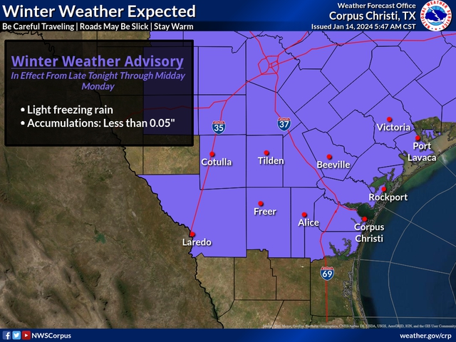
…WINTER WEATHER ADVISORY IN EFFECT...
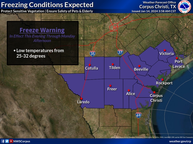
...FREEZE WARNING IN EFFECT...
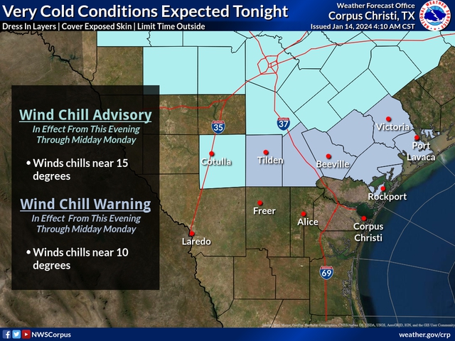
...WIND CHILL WATCHES, ADVISORIES, AND WARNINGS IN EFFECT...
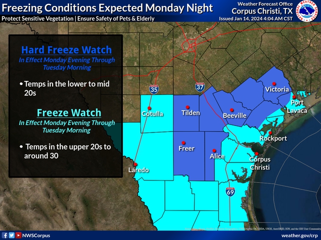
...HARD FREEZE WATCH IN EFFECT...
...GALE WATCH IN EFFECT...
Winter Weather Advisory expanded to include all of South Texas, except for the barrier islands
Freeze Watch upgraded to a Freeze Warning and now includes all of South Texas
Wind Chill Watches, Advisories, Warnings are now in effect
A Gale Watch is now in effect for the adjacent Waters
A Hard Freeze Watch is now in effect
Timing and Overview
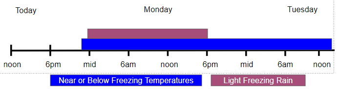
A polar airmass will continue to infiltrate South Texas today through Tuesday. Patchy to areas of light rain and light freezing rain are expected to develop over South Texas after midnight Monday morning. At this time, total accumulations are forecast to remain below 0.05 inch. However, significant uncertainty remains with regard to the total amount of ice accumulation. The combination of wind and temperatures will result in very cold to dangerously cold wind chills over the Victoria Crossroads and over the northern sections of the Brush Country and Rio Grande Plains, late tonight through Monday morning, and over all of South Texas late Monday night through Tuesday morning. In response to a surge of colder air Monday night and Tuesday, very strong offshore flow is expected over the adjacent Waters. The following are the specific hazards:
A Winter Weather Advisory is in effect beginning at 10 PM CST tonight for the Victoria Crossroads, and over the northern sections of the Brush Country and Rio Grande Plains, and begins over the remainder of South Texas (except for the barrier islands) by 3 AM CST Monday. The Advisory ends over the western portions of South Texas by 12 PM Monday, and over the remainder of South Texas by 6 PM CST Monday.
A Wind Chill Advisory is in effect beginning at 10 PM CST tonight, followed by a Wind Chill Warning beginning at 3 AM Monday and ending 12 PM Monday, for the Victoria Crossroads and for northern sections of the Brush Country and Rio Grande Plains.
A Hazard Freeze Watch is in effect beginning from 6 PM CST Monday night to 12 PM CST Tuesday for the Victoria Crossroads, and for portions of the Brush Country and Rio Grande Plains.
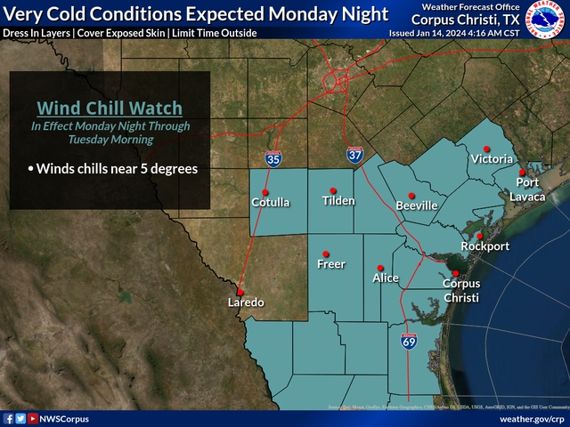
A Wind Chill Watch is in effect for South Texas for late Monday night through Tuesday morning.
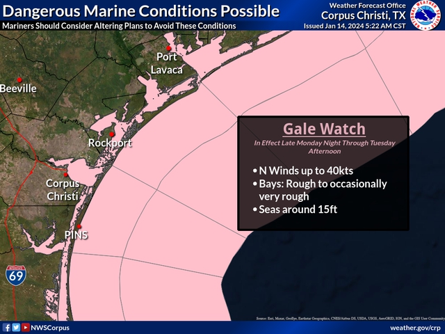
A Gale Watch is in effect for the bays, intracoastal waterways, and adjacent coastal waters for late Monday night through Tuesday afternoon.
Real-time updates will be posted on our Twitter (no account needed). Regional descriptor graphic.
South Texas Hazards
Expected Accumulations
Less than 0.05 inch of ice
Temperatures:
- From the mid 20s to the lower 30s
Wind Chill:
- As low as 15o F to 25o F Monday, and 5o F to 15o F Tuesday
South Texas Impacts
Freezing Rain:
A light glaze of ice may develop on vegetation and outdoor exposed infrastructure. Trace amounts of ice on overpasses/bridges are possible. Caution is advised on bridges and overpasses.
Wind Chill:
Dangerously cold wind chills could result in hypothermia and/or frostbite if precautions are not taken. More information to prevent and/or treat these conditions is available here.
Freeze:
Freezing temperatures may impact young, sensitive plants, pets, and outdoor irrigation systems.
Hard Freeze:
A hard freeze will have a significant impact on sensitive plants and non-native plants, and pets. Any person could suffer hypothermia if exposed to a long duration of extremely cold temperatures. Exposed water pipes could break if exposed to several hours of extreme cold.
Confidence

For Freezing Temperatures

For Dangerously Cold Wind Chills

Forecaster Considerations
There is high confidence that a polar airmass will continue to infiltrate South Texas today through Tuesday. Confidence is high that freezing temperatures will occur tonight over nearly all of South Texas, over much of South Texas Monday, and over all of South Texas Monday night. Confidence is fairly high that dangerous wind chills will occur, especially Monday night. However, confidence is lower with respect to the development of precipitation. At this time, there is an approximately 20 to 30 percent chance for precipitation over South Texas tonight and Monday. If precipitation occurs, atmospheric conditions favor the development of light freezing rain. Thus, the Winter Weather Advisory was issued.